Geolocate

Tui topographic map

Click on the map to display elevation.

About this map

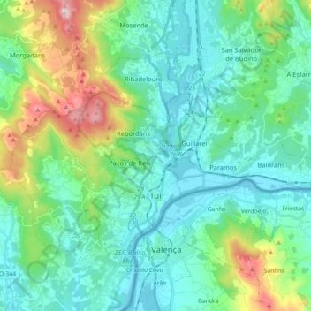
Name: Tui topographic map, elevation, terrain.

Location: Tui, O Baixo Miño, Pontevedra, Galicia, Spain (42.02079 -8.73067 42.11319 -8.55301)

Average elevation: 155 m

Minimum elevation: -1 m

Maximum elevation: 700 m

Other topographic maps

Click on a map to view its topography, its elevation and its terrain.

Vilachán do Monte

Spain > Galicia > O Baixo Miño > Tomiño

Average elevation: 342 m

A Arrotea

Spain > Galicia > O Baixo Miño > Tomiño

Average elevation: 26 m

A Rúa da Cal

Spain > Galicia > O Baixo Miño > O Rosal

Average elevation: 48 m

Gear up for your next adventure:

🧭GPS Handheld Device - Reliable GPS navigation for outdoor adventures
🧢Outdoor Visor - Breathable visor for sunny hikes
🦶Hiking Shoe Insoles - Added support for high arches and long days on feet
🧢Outdoor Cap - Protective cap for sun and rain during hikes
🔋Lithium AA Batteries - Long-lasting power that performs in extreme cold

As an Amazon Associate, this site earns from qualifying purchases at no extra cost to you.