
Thank you for supporting this site ❤️
Make a donation
Make a donation
Gear up for your next adventure:
As an Amazon Associate, this site earns from qualifying purchases at no extra cost to you.
Bernried topographic map
Click on the map to display elevation.
Thank you for supporting this site ❤️
Make a donation
Make a donation
Gear up for your next adventure:
As an Amazon Associate, this site earns from qualifying purchases at no extra cost to you.
About this map
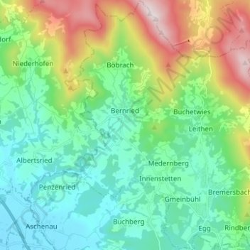
Name: Bernried topographic map, elevation, terrain.
Location: Bernried, Landkreis Deggendorf, Bayern, 94505, Deutschland (48.87332 12.85416 48.95456 12.95233)
Average elevation: 515 m
Minimum elevation: 316 m
Maximum elevation: 1,031 m
Thank you for supporting this site ❤️
Make a donation
Make a donation
Gear up for your next adventure:
As an Amazon Associate, this site earns from qualifying purchases at no extra cost to you.