
Make a donation
Gear up for your next adventure:
As an Amazon Associate, this site earns from qualifying purchases at no extra cost to you.
Smiths Grove topographic map
Click on the map to display elevation.
Make a donation
Gear up for your next adventure:
As an Amazon Associate, this site earns from qualifying purchases at no extra cost to you.
About this map
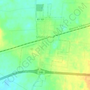
Name: Smiths Grove topographic map, elevation, terrain.
Location: Smiths Grove, Warren County, Kentucky, United States (37.03773 -86.21758 37.06244 -86.19858)
Average elevation: 193 m
Minimum elevation: 179 m
Maximum elevation: 210 m
Make a donation
Gear up for your next adventure:
As an Amazon Associate, this site earns from qualifying purchases at no extra cost to you.
Other topographic maps
Click on a map to view its topography, its elevation and its terrain.
Make a donation
Gear up for your next adventure:
As an Amazon Associate, this site earns from qualifying purchases at no extra cost to you.
Springhill
United States > Kentucky > Warren County > Bowling Green > Springhill
Average elevation: 155 m