Geolocate

Sukamulya topographic map

Click on the map to display elevation.

About this map

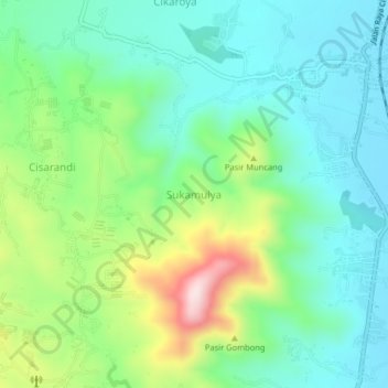
Name: Sukamulya topographic map, elevation, terrain.

Location: Sukamulya, Cianjur, West Java, Java, 43261, Indonesia (-6.92849 107.08518 -6.88849 107.12518)

Average elevation: 569 m

Minimum elevation: 452 m

Maximum elevation: 856 m

Other topographic maps

Click on a map to view its topography, its elevation and its terrain.

Kertajadi

Indonesia > West Java > Cianjur

Average elevation: 108 m

Agrabinta

Indonesia > West Java > Cianjur

Average elevation: 108 m

Cidaun

Indonesia > West Java > Cianjur

Average elevation: 658 m

Karangwangi

Indonesia > West Java > Cianjur

Average elevation: 119 m

Wanasari

Indonesia > West Java > Cianjur

Average elevation: 31 m

Jayapura

Indonesia > West Java > Cianjur

Average elevation: 73 m

Cisalak

Indonesia > West Java > Cianjur

Average elevation: 49 m

Gear up for your next adventure:

🔭Compact Binoculars - Lightweight optics for scouting trails and wildlife
Camping Essentials - All-in-one gear for a comfortable camping trip
🔥Camping Stove - Portable stoves to cook outdoors with ease
🔦LED Headtorch - Bright and durable light for night activities
🪑Insulated Seat Pad - Protect your seat from cold rocks and wet logs

As an Amazon Associate, this site earns from qualifying purchases at no extra cost to you.