Geolocate

Deggendorf topographic map

Click on the map to display elevation.

About this map

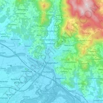
Name: Deggendorf topographic map, elevation, terrain.

Location: Deggendorf, Landkreis Deggendorf, Bavaria, 94469, Germany (48.78686 12.87356 48.90861 13.07415)

Average elevation: 449 m

Minimum elevation: 309 m

Maximum elevation: 1,101 m

Other topographic maps

Click on a map to view its topography, its elevation and its terrain.

Mahd

Germany > Bavaria > Landkreis Deggendorf > Osterhofen > Arbing

Average elevation: 311 m

Bruck

Germany > Bavaria > Landkreis Deggendorf > Deggendorf

Average elevation: 505 m

Neuhausen

Germany > Bavaria > Landkreis Deggendorf

Average elevation: 341 m

Schuhreith

Germany > Bavaria > Landkreis Deggendorf > Mimming

Average elevation: 337 m

Gear up for your next adventure:

🪑Insulated Seat Pad - Protect your seat from cold rocks and wet logs
🦯Trekking Poles - Reduced impact on joints for steep topographic climbs
👟Trail Running Shoes - Agile footwear for fast-paced topographic exploration
💡Compact LED Flashlight - Powerful and portable flashlight for outdoor use
🧢Hiking Hat - Sun-protective and breathable hats for long treks

As an Amazon Associate, this site earns from qualifying purchases at no extra cost to you.