Geolocate

Västervik topographic map

Click on the map to display elevation.

About this map

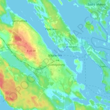
Name: Västervik topographic map, elevation, terrain.

Location: Västervik, Västerviks kommun, Kalmar County, 593 30, Sweden (57.71942 16.59850 57.79942 16.67850)

Average elevation: 12 m

Minimum elevation: -1 m

Maximum elevation: 53 m

Other topographic maps

Click on a map to view its topography, its elevation and its terrain.

Nybro kommun

Sweden > Kalmar County

Average elevation: 109 m

Emmaboda kommun

Sweden > Kalmar County

Average elevation: 141 m

Hultsfreds kommun

Sweden > Kalmar County

Average elevation: 143 m

Emmaboda kommun

Sweden > Kalmar County

Average elevation: 141 m

Hansa City

Sweden > Kalmar County

Average elevation: 7 m

Högsby kommun

Sweden > Kalmar County

Average elevation: 97 m

Store Hindsjön

Sweden > Kalmar County

Average elevation: 118 m

Mönsterås kommun

Sweden > Kalmar County

Average elevation: 26 m

Alen

Sweden > Kalmar County

Average elevation: 142 m

Oskarshamns kommun

Sweden > Kalmar County

Average elevation: 63 m

Kalmar kommun

Sweden > Kalmar County

Average elevation: 28 m

Gear up for your next adventure:

🦟Insect Repellent - Keep mosquitoes and black flies away in wooded areas
💧Filtered Water Bottle - Safe drinking water on the go
🧼Travel Hand Sanitizer - Keep hands clean when water is scarce
🛌Insulated Sleeping Pad - Critical thermal barrier between you and the cold ground
🧤Rechargeable Heated Gloves - Extreme warmth for Canadian winter expeditions

As an Amazon Associate, this site earns from qualifying purchases at no extra cost to you.