
Condado de Pingtung topographic map
Interactive map
Click on the map to display elevation.
About this map
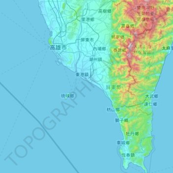
Name: Condado de Pingtung topographic map, elevation, terrain.
Location: Condado de Pingtung, Taiwán (21.89686 120.35290 22.88515 120.90419)
Average elevation: 199 m
Minimum elevation: -3 m
Maximum elevation: 2,963 m
Other topographic maps
Click on a map to view its topography, its elevation and its terrain.
埤麻里
Taiwán > Provincia de Taiwán > 埤麻
埤麻里, 埤麻, Condado de Yunlin, Provincia de Taiwán, 63201, Taiwán
Average elevation: 27 m