Geolocate

Barranquilla topographic map

Click on the map to display elevation.

About this map

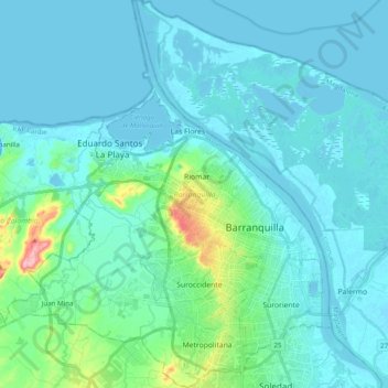
Name: Barranquilla topographic map, elevation, terrain.

Location: Barranquilla, Atlántico, RAP Caribe, Colombia (10.91389 -74.91921 11.10664 -74.75363)

Average elevation: 22 m

Minimum elevation: -4 m

Maximum elevation: 177 m

Other topographic maps

Click on a map to view its topography, its elevation and its terrain.

Barranquilla

Colombia > Atlántico > Barranquilla

Average elevation: 27 m

Puerto Colombia

Colombia > Atlántico > Puerto Colombia

Average elevation: 32 m

Puerto Colombia

Colombia > Atlántico > Puerto Colombia

Average elevation: 32 m

Malambo

Colombia > Atlántico > Malambo

Average elevation: 22 m

Gear up for your next adventure:

🧥Thermal Layer - Insulating layer for cold outdoor conditions
💧Hydration Pack - Hands-free hydration system for long hikes
📷Outdoor Action Camera - Capture high-elevation views and rugged adventures
🥾Hiking Gaiters - Protect legs and shoes from mud, snow, and debris
🧰Survival Kit - Essential gear for emergencies in the wilderness

As an Amazon Associate, this site earns from qualifying purchases at no extra cost to you.