Geolocate

Mariscal topographic map

Click on the map to display elevation.

About this map

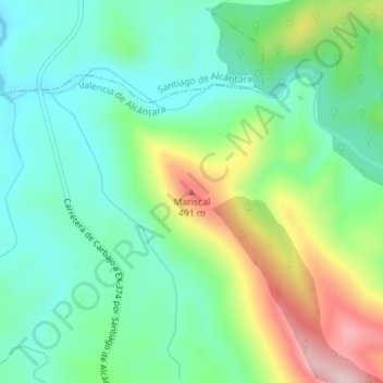
Name: Mariscal topographic map, elevation, terrain.

Location: Mariscal, Valencia de Alcántara, Cáceres, Extremadura, Spain (39.54329 -7.22164 39.54339 -7.22154)

Average elevation: 351 m

Minimum elevation: 266 m

Maximum elevation: 532 m

Other topographic maps

Click on a map to view its topography, its elevation and its terrain.

Gear up for your next adventure:

🥽Outdoor Goggles - Protective eyewear for outdoor activities
🩹Moleskin Blister Pads - Direct protection for painful foot pressure points
🥾Trekking Boots - Durable boots for long-distance trekking
💧Filtered Water Bottle - Safe drinking water on the go
📷Outdoor Action Camera - Capture high-elevation views and rugged adventures

As an Amazon Associate, this site earns from qualifying purchases at no extra cost to you.