Geolocate

Kantamavaripalle topographic map

Click on the map to display elevation.

About this map

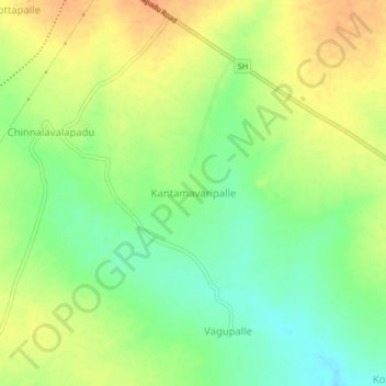
Name: Kantamavaripalle topographic map, elevation, terrain.

Location: Kantamavaripalle, Kanigiri, Prakasam, Andhra Pradesh, India (15.34616 79.52458 15.38616 79.56458)

Average elevation: 88 m

Minimum elevation: 68 m

Maximum elevation: 107 m

Gear up for your next adventure:

🌡️Emergency Mylar Blankets - Compact thermal protection for unexpected nights outdoors
🧣Merino Neck Gaiter - Protects against wind, sun, and cold at high altitudes
🥾Light Trekking Boots - Supportive boots for multi-day treks
🧥Waterproof Hiking Jacket - Protect yourself from rain and wind while hiking
🧦Hiking Liner Socks - Thin base layer to prevent friction and blisters

As an Amazon Associate, this site earns from qualifying purchases at no extra cost to you.