
Thank you for supporting this site ❤️
Make a donation
Make a donation
Gear up for your next adventure:
As an Amazon Associate, this site earns from qualifying purchases at no extra cost to you.
Kinabuan topographic map
Click on the map to display elevation.
Thank you for supporting this site ❤️
Make a donation
Make a donation
Gear up for your next adventure:
As an Amazon Associate, this site earns from qualifying purchases at no extra cost to you.
About this map
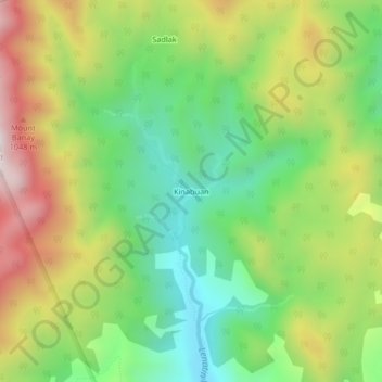
Name: Kinabuan topographic map, elevation, terrain.
Location: Kinabuan, Santa Ines, Rizal, Calabarzon, Philippines (14.73906 121.30007 14.77906 121.34007)
Average elevation: 727 m
Minimum elevation: 362 m
Maximum elevation: 1,252 m
Thank you for supporting this site ❤️
Make a donation
Make a donation
Gear up for your next adventure:
As an Amazon Associate, this site earns from qualifying purchases at no extra cost to you.