
Thank you for supporting this site ❤️
Make a donation
Make a donation
Gear up for your next adventure:
As an Amazon Associate, this site earns from qualifying purchases at no extra cost to you.
Zaccar topographic map
Click on the map to display elevation.
Thank you for supporting this site ❤️
Make a donation
Make a donation
Gear up for your next adventure:
As an Amazon Associate, this site earns from qualifying purchases at no extra cost to you.
About this map
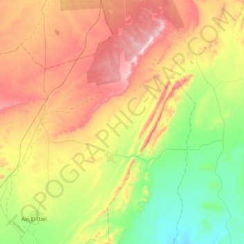
Name: Zaccar topographic map, elevation, terrain.
Location: Zaccar, Aïn El Ibel District, Djelfa, 17003, Algeria (34.32653 3.24509 34.60376 3.45029)
Average elevation: 1,119 m
Minimum elevation: 850 m
Maximum elevation: 1,481 m
Thank you for supporting this site ❤️
Make a donation
Make a donation
Gear up for your next adventure:
As an Amazon Associate, this site earns from qualifying purchases at no extra cost to you.