
Make a donation
Gear up for your next adventure:
As an Amazon Associate, this site earns from qualifying purchases at no extra cost to you.
Gemeinde Wolfsthal topographic map
Click on the map to display elevation.
Make a donation
Gear up for your next adventure:
As an Amazon Associate, this site earns from qualifying purchases at no extra cost to you.
About this map
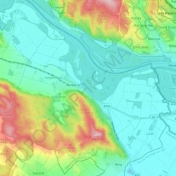
Name: Gemeinde Wolfsthal topographic map, elevation, terrain.
Average elevation: 186 m
Minimum elevation: 126 m
Maximum elevation: 342 m
Make a donation
Gear up for your next adventure:
As an Amazon Associate, this site earns from qualifying purchases at no extra cost to you.
Other topographic maps
Click on a map to view its topography, its elevation and its terrain.
Maria Ellend
Austria > Lower Austria > Bezirk Bruck an der Leitha > Haslau - Maria Ellend
Average elevation: 173 m
Kaiserebersdorf
Austria > Lower Austria > Bezirk Bruck an der Leitha > Vienna
Average elevation: 165 m
Gemeinde Hainburg an der Donau
Austria > Lower Austria > Bezirk Bruck an der Leitha
Average elevation: 202 m
Make a donation
Gear up for your next adventure:
As an Amazon Associate, this site earns from qualifying purchases at no extra cost to you.
Sentahöhle
Austria > Lower Austria > Bezirk Bruck an der Leitha > Gemeinde Prellenkirchen
Average elevation: 202 m