
Make a donation
Gear up for your next adventure:
As an Amazon Associate, this site earns from qualifying purchases at no extra cost to you.
Alder Springs topographic map
Click on the map to display elevation.
Make a donation
Gear up for your next adventure:
As an Amazon Associate, this site earns from qualifying purchases at no extra cost to you.
About this map
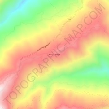
Name: Alder Springs topographic map, elevation, terrain.
Location: Alder Springs, Glenn County, California, United States (39.63099 -122.74555 39.67099 -122.70555)
Average elevation: 1,171 m
Minimum elevation: 739 m
Maximum elevation: 1,510 m
Make a donation
Gear up for your next adventure:
As an Amazon Associate, this site earns from qualifying purchases at no extra cost to you.
Other topographic maps
Click on a map to view its topography, its elevation and its terrain.
Hamilton City
United States > California > Glenn County > Hamilton City
Hamilton City (formerly, Hamilton) is a census-designated place (CDP) in Glenn County, California, United States. The population was 1,759 at the 2010 census, down from 1,903 at the 2000 census. Hamilton City is located 9.5 miles (15 km) east of Orland, and 10 miles west of Chico at an elevation of 151 feet…
Average elevation: 46 m