
Andahuaylas topographic map
Interactive map
Click on the map to display elevation.
About this map
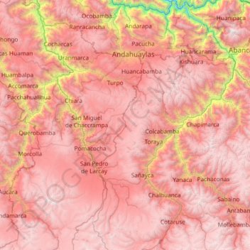
Name: Andahuaylas topographic map, elevation, terrain.
Location: Andahuaylas, Apurímac, Perú (-14.54431 -73.74789 -13.41172 -72.94463)
Average elevation: 3,680 m
Minimum elevation: 1,132 m
Maximum elevation: 5,201 m
Other topographic maps
Click on a map to view its topography, its elevation and its terrain.
Tambobamba
Tambobamba, Huanipaca, Abancay, Apurímac, Perú
Average elevation: 2,775 m
San Jeronimo
Perú > Apurímac > San Jerónimo
San Jeronimo, San Jerónimo, Andahuaylas, Apurímac, 03701, Perú
Average elevation: 3,280 m
Villa El Salvador
Perú > Apurímac > Villa El Salvador
Villa El Salvador, Chincheros, Apurímac, Perú
Average elevation: 3,644 m
Montevideo
Perú > Apurímac > Montevideo
Montevideo, Provincia de Chincheros, Apurímac, Perú
Average elevation: 3,249 m