Geolocate

Salvacion topographic map

Click on the map to display elevation.

About this map

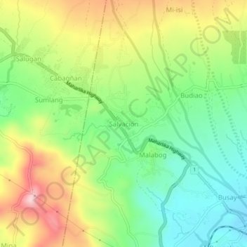
Name: Salvacion topographic map, elevation, terrain.

Location: Salvacion, Daraga, Albay, Bicol Region, 4502, Philippines (13.15676 123.66021 13.19676 123.70021)

Average elevation: 165 m

Minimum elevation: 47 m

Maximum elevation: 336 m

Gear up for your next adventure:

Camping Tent - Weather-resistant tents suitable for 2 to 6 people
🥾Trail Hiking Boots - Supportive boots for rough trails
🥾Hiking Gaiters - Protect legs and shoes from mud, snow, and debris
🔨Vehicle Emergency Tool - Safety tool for remote road trips to trailheads
🚲Heavy Duty Bike Lock - Secure your bike at the trailhead or during stops

As an Amazon Associate, this site earns from qualifying purchases at no extra cost to you.