
Plage d'Agay topographic map
Click on the map to display elevation.
About this map
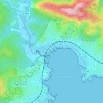
Name: Plage d'Agay topographic map, elevation, terrain.
Average elevation: 54 m
Minimum elevation: -1 m
Maximum elevation: 267 m
Other topographic maps
Click on a map to view its topography, its elevation and its terrain.
Pointe de l’Observatoire
France > Provence-Alpes-Côte d'Azur > Var > Saint-Raphaël
Average elevation: 52 m
Grotte Saint-Barthélemy
France > Provence-Alpes-Côte d'Azur > Var > Saint-Raphaël
Average elevation: 93 m
Pointe de l’Observatoire
France > Provence-Alpes-Côte d'Azur > Var > Saint-Raphaël
Average elevation: 52 m