Geolocate

Arandon topographic map

Click on the map to display elevation.

About this map

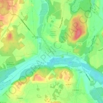
Name: Arandon topographic map, elevation, terrain.

Location: Arandon, Arandon-Passins, La Tour-du-Pin, Isère, Auvergne-Rhône-Alpes, France métropolitaine, 38510, France (45.69280 5.40781 45.73280 5.44781)

Average elevation: 241 m

Minimum elevation: 208 m

Maximum elevation: 287 m

Other topographic maps

Click on a map to view its topography, its elevation and its terrain.

Arandon

France > Auvergne-Rhône-Alpes > Isère > Arandon-Passins

Average elevation: 248 m

Passins

France > Auvergne-Rhône-Alpes > Isère > Arandon-Passins

Passins se trouve approximativement à une altitude de 290 mètres et une superficie de 13,92 km2. Les coordonnées de ce village sont, 45,688 degrés Nord et 5,43 degrés Est.

Average elevation: 263 m

Gear up for your next adventure:

🧥Waterproof Jacket - Lightweight rain jackets for hiking and outdoor activities
🧦Crew Hiking Socks - Comfortable socks for long-distance hikes
🛁Quick-Dry Microfiber Towel - Space-saving towel that dries rapidly on the move
🥾Hiking Shoes - Durable and comfortable shoes for trail hiking
💡Compact LED Flashlight - Powerful and portable flashlight for outdoor use

As an Amazon Associate, this site earns from qualifying purchases at no extra cost to you.