Geolocate

Stendal topographic map

Click on the map to display elevation.

About this map

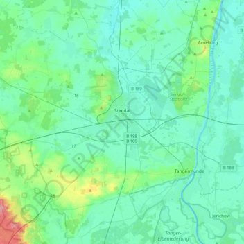
Name: Stendal topographic map, elevation, terrain.

Location: Stendal, Saxony-Anhalt, 39576, Germany (52.48478 11.56867 52.70079 11.97921)

Average elevation: 41 m

Minimum elevation: 24 m

Maximum elevation: 133 m

Gear up for your next adventure:

🕶️Polarized Sunglasses - Protect your eyes with durable polarized lenses
🧰Multitool Knife - Compact and versatile tool for outdoor use
Backpacking Tent - Lightweight tent for long-distance hiking trips
🥾Lightweight Hiking Boots - Boots for comfort and mobility on long hikes
🧤Thermal Hiking Gloves - Grip-enhanced gloves for cold-weather altitude trekking

As an Amazon Associate, this site earns from qualifying purchases at no extra cost to you.