Geolocate

Kuresoi North topographic map

Click on the map to display elevation.

About this map

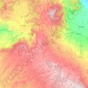
Name: Kuresoi North topographic map, elevation, terrain.

Location: Kuresoi North, Nakuru West, Nakuru, Rift Valley, Kenya (-0.45737 35.41450 -0.05018 35.73757)

Average elevation: 2,451 m

Minimum elevation: 1,714 m

Maximum elevation: 3,045 m

Other topographic maps

Click on a map to view its topography, its elevation and its terrain.

Wild Fire

Kenya > Nakuru > Naivasha > Hells Gate ward > Junction 1

Average elevation: 1,952 m

Kenya

Kenya > Nakuru > Nakuru East > Nakuru East ward

Average elevation: 1,831 m

Fire

Kenya > Nakuru

Average elevation: 1,832 m

Mai Maihu

Kenya > Nakuru

Average elevation: 1,868 m

Gear up for your next adventure:

🧰Survival Kit - Essential gear for emergencies in the wilderness
🔭Compact Monocular - One-handed bird watching and trail spotting
🏕️Camping Hammock - Integrated protection for sleeping between trees
🥾Approach Boots - Comfortable boots for hiking and climbing approaches
🧦Hiking Liner Socks - Thin base layer to prevent friction and blisters

As an Amazon Associate, this site earns from qualifying purchases at no extra cost to you.