Geolocate

Igembe North topographic map

Click on the map to display elevation.

About this map

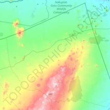
Name: Igembe North topographic map, elevation, terrain.

Location: Igembe North, Meru County, Eastern, Kenya (0.29048 37.77682 0.66863 38.17652)

Average elevation: 1,086 m

Minimum elevation: 710 m

Maximum elevation: 2,025 m

Gear up for your next adventure:

🥾Light Trekking Boots - Supportive boots for multi-day treks
🍽️Titanium Camping Spork - Ultralight and indestructible eating utensil
🥾Trail Running Shoes - Lightweight and durable shoes for trail running
🥾Approach Shoes - Shoes designed for climbing approaches and rugged trails
🥾Mountaineering Boots - Supportive boots for climbing and high-altitude hiking

As an Amazon Associate, this site earns from qualifying purchases at no extra cost to you.