Geolocate

Antioch topographic map

Click on the map to display elevation.

About this map

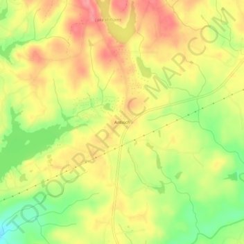
Name: Antioch topographic map, elevation, terrain.

Location: Antioch, Harris County, Georgia, United States (32.65763 -85.07827 32.69763 -85.03827)

Average elevation: 175 m

Minimum elevation: 124 m

Maximum elevation: 214 m

Other topographic maps

Click on a map to view its topography, its elevation and its terrain.

Pine Mountain

United States > Georgia > Harris County

Average elevation: 274 m

Hamilton

United States > Georgia > Harris County

Average elevation: 247 m

Shiloh

United States > Georgia > Harris County

Average elevation: 264 m

Waverly Hall

United States > Georgia > Harris County

Average elevation: 217 m

Whitesville

United States > Georgia > Harris County

Average elevation: 208 m

Gear up for your next adventure:

🧴Waterproofing Spray - Restore the DWR coating on jackets and tents
Lightweight Backpacking Tent - Compact tent for efficient hiking trips
❄️Traction Ice Cleats - Slip-on spikes for icy trails and winter hiking
🚑Survival Whistle - Signal for help across long distances in mountains
🔥Camping Stove - Portable stoves to cook outdoors with ease

As an Amazon Associate, this site earns from qualifying purchases at no extra cost to you.