
Farkë topographic map
Interactive map
Click on the map to display elevation.
About this map
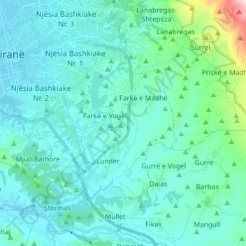
Name: Farkë topographic map, elevation, terrain.
Average elevation: 250 m
Minimum elevation: 101 m
Maximum elevation: 1,340 m
Other topographic maps
Click on a map to view its topography, its elevation and its terrain.
307
Albania > Shqipëria qendrore > Farkë
307, Farkë, Bashkia Tiranë, Condado de Tirana, Shqipëria qendrore, 1045, Albania
Average elevation: 168 m