Geolocate

Jamestown topographic map

Click on the map to display elevation.

About this map

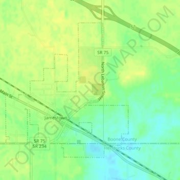
Name: Jamestown topographic map, elevation, terrain.

Location: Jamestown, Boone County, Indiana, United States (39.92068 -86.63875 39.94087 -86.61471)

Average elevation: 292 m

Minimum elevation: 280 m

Maximum elevation: 299 m

Other topographic maps

Click on a map to view its topography, its elevation and its terrain.

Dale

United States > Indiana > Boone County

Average elevation: 291 m

Fayette

United States > Indiana > Boone County > Fayette

Average elevation: 284 m

Gear up for your next adventure:

🧥Softshell Hiking Jacket - The perfect balance of wind protection and breathability
🥾Light Hiking Boots - Lightweight and comfortable boots for day hikes
🔨Vehicle Emergency Tool - Safety tool for remote road trips to trailheads
🧳Compression Sacks - Maximize space in your backpack by shrinking gear
🧥Waterproof Hiking Jacket - Protect yourself from rain and wind while hiking

As an Amazon Associate, this site earns from qualifying purchases at no extra cost to you.