Geolocate

Tricarico topographic map

Click on the map to display elevation.

About this map

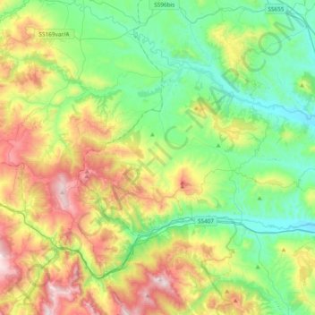
Name: Tricarico topographic map, elevation, terrain.

Location: Tricarico, Matera, Basilicata, 75019, Italy (40.58364 15.94225 40.72536 16.31940)

Average elevation: 467 m

Minimum elevation: 140 m

Maximum elevation: 1,124 m

Gear up for your next adventure:

🧦Merino Wool Socks - Moisture-wicking comfort for long-distance hiking
🔥Camping Stove - Portable stoves to cook outdoors with ease
🔋Emergency Crank Radio - Weather alerts and power without needing batteries
🧦Hiking Liner Socks - Thin base layer to prevent friction and blisters
🧭GPS Handheld Device - Reliable GPS navigation for outdoor adventures

As an Amazon Associate, this site earns from qualifying purchases at no extra cost to you.