
Zakopane topographic map
Interactive map
Click on the map to display elevation.
About this map
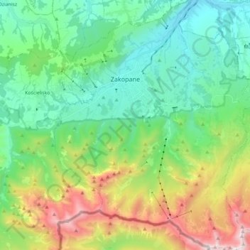
Name: Zakopane topographic map, elevation, terrain.
Location: Zakopane, Tatra County, Lesser Poland Voivodeship, Poland (49.21835 19.90039 49.33317 20.04316)
Average elevation: 1,180 m
Minimum elevation: 742 m
Maximum elevation: 2,250 m
Zakopane has a humid continental climate (Köppen climate classification: Dfb), with the main factor behind its relative coldness compared to the rest of Poland is its altitude. In general, the temperature tends to fall with altitude, therefore Zakopane is almost 3 °C (5.4 °F) colder than northern Kraków, which is more than 600 m (2,000 ft) lower than Zakopane. With higher altitudes, the climate gets even colder, therefore, on the top of Kasprowy Wierch (1,987 m (6,519 ft) above sea level), the climate is tundra-like (Köppen: ET). The tree line is located at about 1,500 m (4,900 ft) above sea level in the Tatra Mountains.
Other topographic maps
Click on a map to view its topography, its elevation and its terrain.
Wielki Giewont
Poland > Lesser Poland Voivodeship > Tatra County > Zakopane
Wielki Giewont, Zakopane, Tatra County, Lesser Poland Voivodeship, Poland
Average elevation: 1,478 m
Sarnia Skała
Poland > Lesser Poland Voivodeship > Tatra County > Zakopane
Sarnia Skała, Zakopane, Tatra County, Lesser Poland Voivodeship, 34-500, Poland
Average elevation: 1,206 m
Tatry
Poland > Lesser Poland Voivodeship > Tatra County > Zakopane
Tatry, Zakopane, Tatra County, Lesser Poland Voivodeship, Poland
Average elevation: 1,647 m
Zakopane
Poland > Lesser Poland Voivodeship > Tatra County
Zakopane, Tatra County, Lesser Poland Voivodeship, Poland
Average elevation: 1,180 m
Bukowina Tatrzańska
Poland > Lesser Poland Voivodeship > Tatra County
Bukowina Tatrzańska, gmina Bukowina Tatrzańska, Tatra County, Lesser Poland Voivodeship, 34-530, Poland
Average elevation: 886 m