
Make a donation
Gear up for your next adventure:
As an Amazon Associate, this site earns from qualifying purchases at no extra cost to you.
Janesville topographic map
Click on the map to display elevation.
Make a donation
Gear up for your next adventure:
As an Amazon Associate, this site earns from qualifying purchases at no extra cost to you.
Janesville
According to the United States Census Bureau, the city has a total area of 34.76 square miles (90.03 km2), of which 34.16 square miles (88.47 km2) is land and 0.6 square miles (1.55 km2) is water. The city is divided by the Rock River. Elevation is 837 ft, or 255 m.
Make a donation
Gear up for your next adventure:
As an Amazon Associate, this site earns from qualifying purchases at no extra cost to you.
About this map
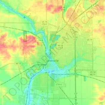
Name: Janesville topographic map, elevation, terrain.
Location: Janesville, Rock County, Wisconsin, United States (42.60514 -89.08051 42.75897 -88.93888)
Average elevation: 264 m
Minimum elevation: 229 m
Maximum elevation: 320 m
Make a donation
Gear up for your next adventure:
As an Amazon Associate, this site earns from qualifying purchases at no extra cost to you.