Geolocate

Anserma topographic map

Click on the map to display elevation.

About this map

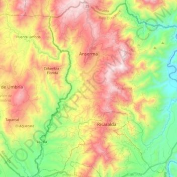
Name: Anserma topographic map, elevation, terrain.

Location: Anserma, Bajo Occidente, Caldas, Colombia (5.11225 -75.83857 5.28575 -75.66208)

Average elevation: 1,366 m

Minimum elevation: 745 m

Maximum elevation: 2,089 m

Gear up for your next adventure:

🦶Anti-Blister Balm - Prevents friction and hotspots during long ascents
🧦Hiking Socks - Moisture-wicking and comfortable socks for long hikes
🧢Outdoor Visor - Breathable visor for sunny hikes
🥾Light Trekking Boots - Supportive boots for multi-day treks
🥾Light Hiking Boots - Lightweight and comfortable boots for day hikes

As an Amazon Associate, this site earns from qualifying purchases at no extra cost to you.