
Make a donation
Gear up for your next adventure:
As an Amazon Associate, this site earns from qualifying purchases at no extra cost to you.
Tizgui topographic map
Click on the map to display elevation.
Make a donation
Gear up for your next adventure:
As an Amazon Associate, this site earns from qualifying purchases at no extra cost to you.
About this map
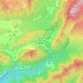
Name: Tizgui topographic map, elevation, terrain.
Average elevation: 834 m
Minimum elevation: 534 m
Maximum elevation: 1,187 m
Make a donation
Gear up for your next adventure:
As an Amazon Associate, this site earns from qualifying purchases at no extra cost to you.
Other topographic maps
Click on a map to view its topography, its elevation and its terrain.
Tamri
Maroc > Souss-Massa > cercle d'Agadir-Atlantique
La commune se trouve à environ 60 km au nord d'Agadir avec une superficie de 868 km2. Elle est dominée par les montagnes du haut Atlas qui atteignent 1700 mètres d'altitude et est bordée à l'ouest par l'océan Atlantique. Le climat de la commune est considéré semi-aride ; elle reçoit des…
Average elevation: 159 m