Geolocate

Mariotto topographic map

Click on the map to display elevation.

About this map

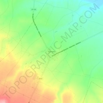
Name: Mariotto topographic map, elevation, terrain.

Location: Mariotto, Bitonto, Bari, Puglia, Italia (41.03181 16.54220 41.07181 16.58220)

Average elevation: 241 m

Minimum elevation: 189 m

Maximum elevation: 312 m

Gear up for your next adventure:

🚲Handlebar Phone Mount - View topographic-map.com live while cycling
🎒Backpack Rain Cover - External shield to keep your entire pack dry
🧭Orienteering Kit - Tools for map reading and navigation in the wild
🥾Waterproof Trail Shoes - Shoes designed to handle wet terrain
🥾Mountain Trail Shoes - High-traction shoes for mountain trails

As an Amazon Associate, this site earns from qualifying purchases at no extra cost to you.