Geolocate

Ayotlán topographic map

Click on the map to display elevation.

About this map

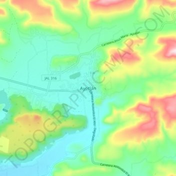
Name: Ayotlán topographic map, elevation, terrain.

Location: Ayotlán, Región Ciénega, Jalisco, 47930, Mexico (20.48873 -102.36905 20.56873 -102.28905)

Average elevation: 1,697 m

Minimum elevation: 1,565 m

Maximum elevation: 1,980 m

Gear up for your next adventure:

🥾Trekking Boots - Durable boots for long-distance trekking
🧴Outdoor Sunscreen - High SPF protection for high-altitude UV exposure
👖Convertible Hiking Pants - Zip-off legs to adapt to changing weather conditions
🕯️Camping Lantern - Illuminates your entire campsite with high-efficiency LEDs
🧢Outdoor Visor - Breathable visor for sunny hikes

As an Amazon Associate, this site earns from qualifying purchases at no extra cost to you.