Geolocate

Knåda topographic map

Click on the map to display elevation.

About this map

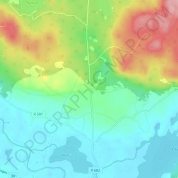
Name: Knåda topographic map, elevation, terrain.

Location: Knåda, Ovanåkers kommun, Gävleborg County, 828 94, Sweden (61.36853 15.87733 61.40853 15.91733)

Average elevation: 196 m

Minimum elevation: 151 m

Maximum elevation: 295 m

Other topographic maps

Click on a map to view its topography, its elevation and its terrain.

Gran

Sweden > Gävleborg County > Gnarp District

Average elevation: 0 m

Ljusdals kommun

Sweden > Gävleborg County

Average elevation: 315 m

Disan

Sweden > Gävleborg County

Average elevation: 43 m

Hamra

Sweden > Gävleborg County

Average elevation: 437 m

Hamra

Sweden > Gävleborg County

Average elevation: 437 m

Hamra

Sweden > Gävleborg County

Average elevation: 437 m

Söderhamns kommun

Sweden > Gävleborg County

Average elevation: 67 m

Gnarp District

Sweden > Gävleborg County

Average elevation: 32 m

Hudiksvalls kommun

Sweden > Gävleborg County

Average elevation: 95 m

Gävle kommun

Sweden > Gävleborg County

Average elevation: 61 m

Gävle

Sweden > Gävleborg County

Average elevation: 28 m

Ovanåkers kommun

Sweden > Gävleborg County

Average elevation: 269 m

Hofors kommun

Sweden > Gävleborg County

Average elevation: 147 m

Gear up for your next adventure:

🥾Light Hiking Boots - Lightweight and comfortable boots for day hikes
💡Solar Camping Lamp - Eco-friendly lighting for campsites
🪜Heavy Duty Carabiners - Multi-use clips for securing gear to your backpack
🧢Outdoor Visor - Breathable visor for sunny hikes
🩹Moleskin Blister Pads - Direct protection for painful foot pressure points

As an Amazon Associate, this site earns from qualifying purchases at no extra cost to you.