
Thank you for supporting this site ❤️
Make a donation
Make a donation
Gear up for your next adventure:
As an Amazon Associate, this site earns from qualifying purchases at no extra cost to you.
Samboneto topographic map
Click on the map to display elevation.
Thank you for supporting this site ❤️
Make a donation
Make a donation
Gear up for your next adventure:
As an Amazon Associate, this site earns from qualifying purchases at no extra cost to you.
About this map
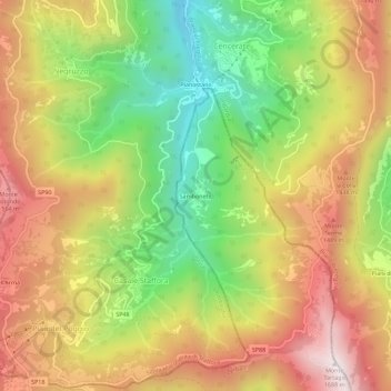
Name: Samboneto topographic map, elevation, terrain.
Location: Samboneto, Zerba, Piacenza, Emilia-Romagna, Italia (44.68309 9.21521 44.72309 9.25521)
Average elevation: 1,216 m
Minimum elevation: 744 m
Maximum elevation: 1,679 m
Thank you for supporting this site ❤️
Make a donation
Make a donation
Gear up for your next adventure:
As an Amazon Associate, this site earns from qualifying purchases at no extra cost to you.