
Make a donation
Gear up for your next adventure:
As an Amazon Associate, this site earns from qualifying purchases at no extra cost to you.
Klosterneuburg topographic map
Click on the map to display elevation.
Make a donation
Gear up for your next adventure:
As an Amazon Associate, this site earns from qualifying purchases at no extra cost to you.
About this map
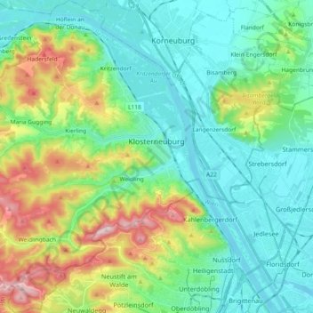
Name: Klosterneuburg topographic map, elevation, terrain.
Location: Klosterneuburg, Bezirk Tulln, Lower Austria, Austria (48.23832 16.20148 48.35954 16.36318)
Average elevation: 252 m
Minimum elevation: 154 m
Maximum elevation: 522 m
Make a donation
Gear up for your next adventure:
As an Amazon Associate, this site earns from qualifying purchases at no extra cost to you.
Other topographic maps
Click on a map to view its topography, its elevation and its terrain.
Baumgarten am Tullnerfeld
Austria > Lower Austria > Bezirk Tulln > Gemeinde Judenau-Baumgarten
Average elevation: 213 m
Make a donation
Gear up for your next adventure:
As an Amazon Associate, this site earns from qualifying purchases at no extra cost to you.
Maria Gugging
Austria > Lower Austria > Bezirk Tulln > Gemeinde Klosterneuburg
Average elevation: 323 m
Fels am Wagram
Austria > Lower Austria > Bezirk Tulln > Gemeinde Fels am Wagram > Fels am Wagram
Average elevation: 213 m
Make a donation
Gear up for your next adventure:
As an Amazon Associate, this site earns from qualifying purchases at no extra cost to you.