Geolocate

Telde topographic map

Click on the map to display elevation.

About this map

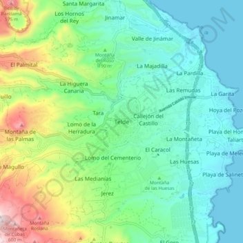
Name: Telde topographic map, elevation, terrain.

Location: Telde, Las Palmas, Canary Islands, 35200, Spain (27.95845 -15.45668 28.03845 -15.37668)

Average elevation: 170 m

Minimum elevation: -1 m

Maximum elevation: 638 m

Gear up for your next adventure:

🥾Trail Running Shoes - Lightweight and durable shoes for trail running
💧Hydration Pack - Hands-free hydration system for long hikes
👟Leg Gaiters - Keep debris, mud, and snow out of your boots
🦌Outdoor Trail Camera - Monitor wildlife activity near your favorite spots
🧭Orienteering Kit - Tools for map reading and navigation in the wild

As an Amazon Associate, this site earns from qualifying purchases at no extra cost to you.