Geolocate

Bolivar topographic map

Click on the map to display elevation.

About this map

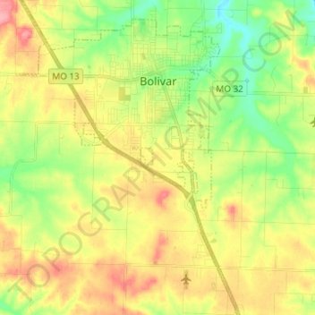
Name: Bolivar topographic map, elevation, terrain.

Location: Bolivar, Polk County, Missouri, 65613, United States (37.53861 -93.46675 37.63623 -93.37902)

Average elevation: 334 m

Minimum elevation: 288 m

Maximum elevation: 387 m

Other topographic maps

Click on a map to view its topography, its elevation and its terrain.

Brighton

United States > Missouri > Polk County

Average elevation: 350 m

Gear up for your next adventure:

🎒Hiking Backpack - Lightweight and ergonomic backpacks for day hikes or multi-day treks
🪑Insulated Seat Pad - Protect your seat from cold rocks and wet logs
🥾Light Trekking Boots - Supportive boots for multi-day treks
🧦Hiking Liner Socks - Thin base layer to prevent friction and blisters
🥾Durable Hiking Shoes - Long-lasting shoes for frequent hiking

As an Amazon Associate, this site earns from qualifying purchases at no extra cost to you.