Geolocate

Mont-Joli topographic map

Click on the map to display elevation.

About this map

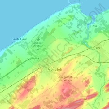
Name: Mont-Joli topographic map, elevation, terrain.

Location: Mont-Joli, La Mitis, Bas-Saint-Laurent, Quebec, Canada (48.54884 -68.25211 48.64440 -68.12504)

Average elevation: 63 m

Minimum elevation: -4 m

Maximum elevation: 214 m

La Mitis trails, hiking, mountain biking, running and outdoor activities

Other topographic maps

Click on a map to view its topography, its elevation and its terrain.

Mont Comi

Canada > Quebec > La Mitis > Saint-Donat

Average elevation: 420 m

Parc du Bois à Ben

Canada > Quebec > La Mitis > Mont-Joli

Average elevation: 65 m

Gear up for your next adventure:

🧥Waterproof Pants - Keep dry during rainy hiking conditions
🥾Mountain Hiking Boots - High-traction boots for rocky terrain
👖Convertible Hiking Pants - Zip-off legs to adapt to changing weather conditions
🧢Sun Hat - Wide-brim hat for sun protection
🚲Heavy Duty Bike Lock - Secure your bike at the trailhead or during stops

As an Amazon Associate, this site earns from qualifying purchases at no extra cost to you.