Geolocate

Douglas topographic map

Click on the map to display elevation.

About this map

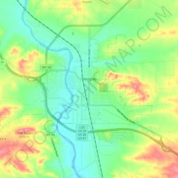
Name: Douglas topographic map, elevation, terrain.

Location: Douglas, Converse County, Wyoming, 82633, United States (42.73272 -105.44574 42.77789 -105.34510)

Average elevation: 1,492 m

Minimum elevation: 1,453 m

Maximum elevation: 1,559 m

Other topographic maps

Click on a map to view its topography, its elevation and its terrain.

Bill

United States > Wyoming > Converse County

Average elevation: 1,434 m

Shawnee

United States > Wyoming > Converse County

Average elevation: 1,542 m

Gear up for your next adventure:

🧢Hiking Hat - Sun-protective and breathable hats for long treks
🧴Bear Spray Holster - Quick-access carry for essential Canadian wilderness safety
🧭GPS Tracker - Track your location in remote areas safely
🦶Hiking Shoe Insoles - Added support for high arches and long days on feet
🧶550 Survival Paracord - Versatile utility cord for emergency repairs and rigging

As an Amazon Associate, this site earns from qualifying purchases at no extra cost to you.