
Thank you for supporting this site ❤️
Make a donation
Make a donation
Gear up for your next adventure:
As an Amazon Associate, this site earns from qualifying purchases at no extra cost to you.
Pokhra topographic map
Click on the map to display elevation.
Thank you for supporting this site ❤️
Make a donation
Make a donation
Gear up for your next adventure:
As an Amazon Associate, this site earns from qualifying purchases at no extra cost to you.
About this map
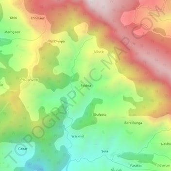
Name: Pokhra topographic map, elevation, terrain.
Location: Pokhra, Didihat, Pithoragarh district, Uttarakhand, India (29.75624 80.17989 29.79624 80.21989)
Average elevation: 1,565 m
Minimum elevation: 1,034 m
Maximum elevation: 2,180 m
Thank you for supporting this site ❤️
Make a donation
Make a donation
Gear up for your next adventure:
As an Amazon Associate, this site earns from qualifying purchases at no extra cost to you.