Geolocate

Castellbisbal topographic map

Click on the map to display elevation.

Castellbisbal

El relieve del municipio está caracterizado por el valle del río Llobregat por el sur y por una zona más montañosa con torrentes y rieras por el norte que supera los 200 metros de altitud. La altitud oscila entre los 267 metros al norte y los 40 metros a orillas del río Llobregat. El pueblo se alza a 152 metros sobre el nivel del mar.

About this map

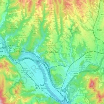
Name: Castellbisbal topographic map, elevation, terrain.

Location: Castellbisbal, Vallés Occidental, Barcelona, Cataluña, 08755, España (41.43651 1.94330 41.51651 2.02330)

Average elevation: 131 m

Minimum elevation: 25 m

Maximum elevation: 351 m

Gear up for your next adventure:

🥾Mountain Trail Shoes - High-traction shoes for mountain trails
💧Collapsible Water Bottle - Space-saving water bottle for outdoor activities
👟Sport Hiking Sandals - Breathable footwear for water crossings and camp rest
🛌Insulated Sleeping Pad - Critical thermal barrier between you and the cold ground
🧦Thermal Socks - Warm socks for winter hiking or camping

As an Amazon Associate, this site earns from qualifying purchases at no extra cost to you.