Geolocate

Honda topographic map

Click on the map to display elevation.

About this map

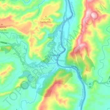
Name: Honda topographic map, elevation, terrain.

Location: Honda, Tolima, 732040, Colombia (5.17042 -74.77619 5.25042 -74.69619)

Average elevation: 327 m

Minimum elevation: 182 m

Maximum elevation: 650 m

Gear up for your next adventure:

👟Trail Running Shoes - Agile footwear for fast-paced topographic exploration
🧼Biodegradable Camp Soap - Environmentally friendly cleaning for gear and body
🔋Emergency Crank Radio - Weather alerts and power without needing batteries
Lightweight Backpacking Tent - Compact tent for efficient hiking trips
🧢Sun Protection Cap - Breathable cap to protect from sun exposure

As an Amazon Associate, this site earns from qualifying purchases at no extra cost to you.