Geolocate

Neuss topographic map

Click on the map to display elevation.

About this map

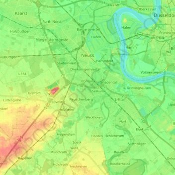
Name: Neuss topographic map, elevation, terrain.

Location: Neuss, Rhein-Kreis Neuss, North Rhine-Westphalia, Germany (51.11676 6.61482 51.23561 6.79836)

Average elevation: 44 m

Minimum elevation: 20 m

Maximum elevation: 83 m

Other topographic maps

Click on a map to view its topography, its elevation and its terrain.

Gear up for your next adventure:

🧰Emergency Multi-Tool - Compact multi-tool for outdoor survival
🐕Hiking Dog Pack - Let your canine companion carry their own water and food
🛶Kayak Accessories - Essential gear for safe and fun kayaking adventures
Camping Groundsheet - Protect your tent from moisture and dirt
Backpacking Tent - Lightweight tent for long-distance hiking trips

As an Amazon Associate, this site earns from qualifying purchases at no extra cost to you.