Geolocate

Wangen topographic map

Click on the map to display elevation.

About this map

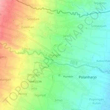
Name: Wangen topographic map, elevation, terrain.

Location: Wangen, Klaten, Central Java, Java, 57482, Indonesia (-7.62292 110.62803 -7.58292 110.66803)

Average elevation: 210 m

Minimum elevation: 166 m

Maximum elevation: 277 m

Other topographic maps

Click on a map to view its topography, its elevation and its terrain.

Jaten

Indonesia > Central Java > Klaten

Average elevation: 117 m

Bendo

Indonesia > Central Java > Klaten

Average elevation: 110 m

Depra Sentono

Indonesia > Central Java > Klaten

Average elevation: 102 m

Pugeran

Indonesia > Central Java > Klaten

Average elevation: 97 m

Sidorejo

Indonesia > Central Java > Klaten

Average elevation: 1,110 m

Sajen

Indonesia > Central Java > Klaten

Average elevation: 105 m

Taji

Indonesia > Central Java > Klaten

Average elevation: 96 m

Bulan

Indonesia > Central Java > Klaten

Average elevation: 120 m

Kemalang

Indonesia > Central Java > Klaten

Average elevation: 844 m

RT 11

Indonesia > Central Java > Klaten

Average elevation: 97 m

Gear up for your next adventure:

🥾Approach Boots - Comfortable boots for hiking and climbing approaches
🦌Outdoor Trail Camera - Monitor wildlife activity near your favorite spots
🧭GPS Handheld Device - Reliable GPS navigation for outdoor adventures
🛌Down Sleeping Bag - Superior warmth-to-weight ratio for cold nights
🧥Waterproof Jacket - Lightweight rain jackets for hiking and outdoor activities

As an Amazon Associate, this site earns from qualifying purchases at no extra cost to you.