
Make a donation
Gear up for your next adventure:
As an Amazon Associate, this site earns from qualifying purchases at no extra cost to you.
Cannes topographic map
Click on the map to display elevation.
Make a donation
Gear up for your next adventure:
As an Amazon Associate, this site earns from qualifying purchases at no extra cost to you.
Cannes
Cannes est située dans la communauté d'agglomération des Pays de Lérins, à l’ouest du département des Alpes-Maritimes sur la Côte d'Azur dans la région Provence-Alpes-Côte d'Azur (PACA), sur la rive est de la plaine alluviale de la Siagne, en bordure de la mer Méditerranée dans ce qui est couramment appelé la baie de Cannes ou golfe de La Napoule. Le territoire communal s’inscrit dans un croissant orienté vers le sud, long de 9 kilomètres d’ouest en est et large de 5 kilomètres du nord au sud, occupant une superficie totale de 1 962 hectares. L’Institut national de l'information géographique et forestière attribue les coordonnées géographiques 43° 33' 29" nord et 07° 01' 04" est au point central de ce territoire. La commune est irriguée par le ruisseau du Béal et la rivière la Grande Frayère, sa géographie est caractérisée par une relative disparité des élévations, avec une bande côtière et des collines et pitons comme le Suquet, la Croix-des-Gardes ou le Bois-de-la-Maure où se trouve le point culminant de la commune à 260 m d’altitude.
Make a donation
Gear up for your next adventure:
As an Amazon Associate, this site earns from qualifying purchases at no extra cost to you.
About this map
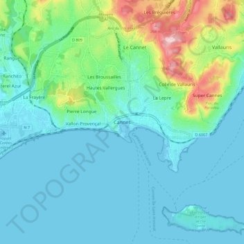
Name: Cannes topographic map, elevation, terrain.
Average elevation: 54 m
Minimum elevation: -4 m
Maximum elevation: 284 m
Make a donation
Gear up for your next adventure:
As an Amazon Associate, this site earns from qualifying purchases at no extra cost to you.