Geolocate

Palestine topographic map

Click on the map to display elevation.

About this map

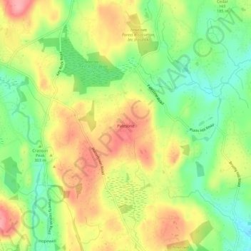
Name: Palestine topographic map, elevation, terrain.

Location: Palestine, Newtown, Western Connecticut Planning Region, Connecticut, 06470, United States (41.34565 -73.33984 41.38565 -73.29984)

Average elevation: 184 m

Minimum elevation: 131 m

Maximum elevation: 241 m

Other topographic maps

Click on a map to view its topography, its elevation and its terrain.

Gear up for your next adventure:

🔋Solar Power Bank - Keep your GPS and devices charged during long outdoor trips
🚲MTB Frame Bag - Carry tools and maps directly on your bicycle frame
🧴Sunscreen SPF - Broad-spectrum sunscreen for outdoor activities
🔪Outdoor Multitool - Versatile tool for repairs and food prep in the wild
👟Sport Hiking Sandals - Breathable footwear for water crossings and camp rest

As an Amazon Associate, this site earns from qualifying purchases at no extra cost to you.