
Make a donation
Gear up for your next adventure:
As an Amazon Associate, this site earns from qualifying purchases at no extra cost to you.
Chavaroche topographic map
Click on the map to display elevation.
Make a donation
Gear up for your next adventure:
As an Amazon Associate, this site earns from qualifying purchases at no extra cost to you.
Chavaroche
Le puy Chavaroche est un sommet français faisant partie des monts du Cantal. Il culmine à 1 736 m d'altitude. Il s'y trouve « un homme de pierre » impressionnant où l'on dépose une pierre pour laisser une trace de son passage. Le puy Chavaroche est traversé par le sentier de grande randonnée 400 (GR 400).
Make a donation
Gear up for your next adventure:
As an Amazon Associate, this site earns from qualifying purchases at no extra cost to you.
About this map
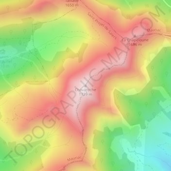
Name: Chavaroche topographic map, elevation, terrain.
Average elevation: 1,425 m
Minimum elevation: 1,068 m
Maximum elevation: 1,728 m
Make a donation
Gear up for your next adventure:
As an Amazon Associate, this site earns from qualifying purchases at no extra cost to you.
Other topographic maps
Click on a map to view its topography, its elevation and its terrain.
Parking Auberge
France > Auvergne-Rhône-Alpes > Cantal > Saint-Projet-de-Salers
Average elevation: 1,197 m