
Sandaun topographic map
Interactive map
Click on the map to display elevation.
About this map
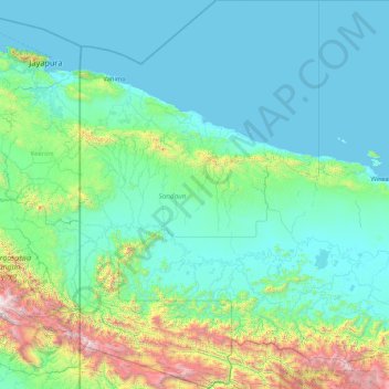
Name: Sandaun topographic map, elevation, terrain.
Location: Sandaun, Momase Region, Papua New Guinea (-5.37898 141.00000 -2.00000 143.08333)
Average elevation: 415 m
Minimum elevation: 0 m
Maximum elevation: 4,099 m
Other topographic maps
Click on a map to view its topography, its elevation and its terrain.
Vanimo District
Vanimo District, Sandaun, Momase Region, Papua New Guinea
Average elevation: 185 m
Anguganak
Anguganak, Sandaun, Momase Region, Papua New Guinea
Average elevation: 331 m
Aitape District
Papua New Guinea > Sandaun > Aitape District
Aitape District, Sandaun, Momase Region, Papua New Guinea
Average elevation: 150 m