
Thank you for supporting this site ❤️
Make a donation
Make a donation
Gear up for your next adventure:
As an Amazon Associate, this site earns from qualifying purchases at no extra cost to you.
Grabs topographic map
Click on the map to display elevation.
Thank you for supporting this site ❤️
Make a donation
Make a donation
Gear up for your next adventure:
As an Amazon Associate, this site earns from qualifying purchases at no extra cost to you.
About this map
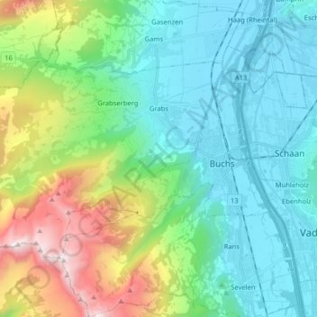
Name: Grabs topographic map, elevation, terrain.
Location: Grabs, Wahlkreis Werdenberg, St. Gallen, 9472, Switzerland (47.13054 9.31761 47.19819 9.47687)
Average elevation: 916 m
Minimum elevation: 436 m
Maximum elevation: 2,353 m
Thank you for supporting this site ❤️
Make a donation
Make a donation
Gear up for your next adventure:
As an Amazon Associate, this site earns from qualifying purchases at no extra cost to you.