
Plateau de Haye topographic map
Interactive map
Click on the map to display elevation.
About this map
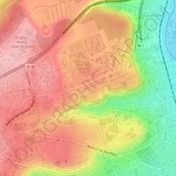
Name: Plateau de Haye topographic map, elevation, terrain.
Average elevation: 298 m
Minimum elevation: 193 m
Maximum elevation: 366 m
Other topographic maps
Click on a map to view its topography, its elevation and its terrain.
Parc de la Pépinière
France > Grand Est > Meurthe-et-Moselle > Nancy
Parc de la Pépinière, Saint-Nicolas - Charles III - Ville vieille - Trois Maisons - Léopold, Nancy, Meurthe-et-Moselle, Grand Est, France métropolitaine, 54100, France
Average elevation: 210 m
Poincaré - Foch - Anatole France - Croix de Bourgogne
France > Grand Est > Meurthe-et-Moselle > Nancy
Poincaré - Foch - Anatole France - Croix de Bourgogne, Nancy, Meurthe-et-Moselle, Grand Est, France métropolitaine, 54000, France
Average elevation: 239 m