Geolocate

Valley Center topographic map

Click on the map to display elevation.

About this map

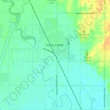
Name: Valley Center topographic map, elevation, terrain.

Location: Valley Center, Sedgwick County, Kansas, United States (37.79592 -97.40626 37.86153 -97.33409)

Average elevation: 413 m

Minimum elevation: 405 m

Maximum elevation: 433 m

Other topographic maps

Click on a map to view its topography, its elevation and its terrain.

Murray Gill

United States > Kansas > Sedgwick County

Average elevation: 395 m

Furley

United States > Kansas > Sedgwick County

Average elevation: 426 m

Sand Burr Hill

United States > Kansas > Sedgwick County > Wichita

Average elevation: 385 m

Wichita

United States > Kansas > Sedgwick County > Wichita

Average elevation: 410 m

Gear up for your next adventure:

🧥Waterproof Jacket - Lightweight rain jackets for hiking and outdoor activities
🛏️Camping Sleeping Mat - Comfortable mats for sleeping outdoors
🚲Heavy Duty Bike Lock - Secure your bike at the trailhead or during stops
🥾Hiking Leggings - Comfortable leggings for outdoor activities
🛶Waterproof Dry Bags - Keep electronics and clothes dry during river crossings

As an Amazon Associate, this site earns from qualifying purchases at no extra cost to you.